Short note on Spatial Data Mining/Mining Spatial Data.
Mining Spatial Data
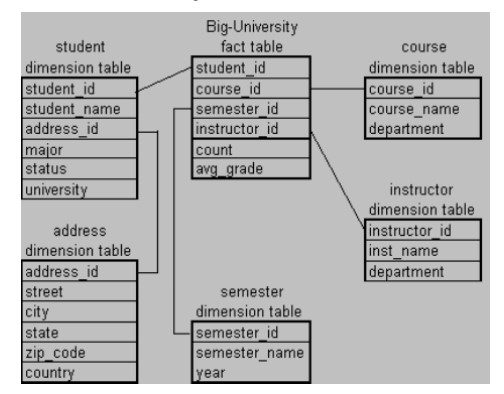
Spatial data mining discovers patterns and knowledge from spatial data. Spatial data, in many cases, refer to geospace-related data stored in geospatial data repositories. The data can be in "vector" or "raster" formats, or in the form of imagery and geo-referenced multimedia. Recently, large geographic data warehouses have been constructed by integrating thematic and geographically referenced data from multiple sources. From there, we can construct spatial data cubes that contain spatial dimensions and measures, and support spatial OLAP for multidimensional spatial data analysis. Spatial data mining can be performed on spatial data warehouses, spatial databases, and other geospatial data repositories. Popular topics on geographic knowledge discovery and spatial data mining include mining spatial associations and co-location patterns, spatial clustering, spatial classification, spatial modeling, and spatial trend and outlier analysis.
OR,
Spatial Data Mining
A spatial database stores a large amount of space-related data, such as maps, preprocessed remote sensing or medical imaging data, and VLSI chip layout data. Spatial databases have many features that distinguish them from relational databases. They carry topological and/or distance information.
Spatial data mining refers to the extraction of knowledge, spatial relationships, or other interesting patterns not explicitly stored in spatial databases. Such mining demands the integration of data mining with spatial database technologies. It can be used for understanding spatial data, discovering spatial relationships and relationships between spatial and non-spatial data.
It is expected to have wide applications in geographic information systems, marketing, remote sensing, image database exploration, medical imaging, navigation, traffic control, environmental studies, and many other areas where spatial data are used. A crucial challenge to spatial data mining is the exploration of efficient spatial data mining techniques due to the huge amount of spatial data and the complexity of spatial data types and spatial access methods.
OR,
Spatial Data Mining
- Spatial data mining is the process of discovering interesting, useful, non-trivial patterns from large spatial datasets.
- Spatial Data Mining = Mining Spatial Data Sets (i.e. Data Mining + Geographic Information Systems)
- Spatial data refer to any data about objects that occupy real physical space.
- Attributes for spatial data usually will include spatial information. Spatial information (metadata) is used to describe objects in space.
- Spatial information includes geometric metadata (e.g., location, shape, size, distance, area, perimeter) and topological metadata (e.g., “neighbor of”, “adjacent to”, “included in”, “includes”).
- Spatial data can contain both spatial and non-spatial features. Spatial data has a location or geo-referenced features like:
– Address, latitude/longitude (explicit)
– Location-based partitions in databases (implicit)
- Spatial Data Warehouse is an integrated, subject-oriented, time-variant, and nonvolatile spatial data repository for data analysis and decision making.
- Spatial Data Integration is a big issue. It deals with:
– Structure-specific formats (raster vs. vector-based, Object-Oriented vs. relational models, different storage and indexing, etc.)
– Vendor-specific formats (ESRI, MapInfo, Integraph, etc.)
- Spatial Data Cube is a multidimensional spatial database where both dimensions and measures may contain spatial components


Comments
Post a Comment